We continue the route along the section of the Way of Saint James between Triacastela and Samos. We have just left San Cristovo do Real which already belongs to the municipality of Samos. We will pass through Renche and Lastres, to arrive at Freituxe, where this Part 2 ends. The Way and that is all.
Click Here for Part 1.
The yellow arrows devised and painted by Elías Valiña parish priest in O Cebreiro along the Way to guide pilgrims. They leave no doubt on the entire stretch of what is the right way to follow.

The numbers shown underneath the photos are the map coordinates of the location from where each photo was taken.
We can see in this link our pilgrimage by the Way of Saint James in Galicia from O Cebreiro: Click Here.
A fallen tree.

The path forks at this point. On the left you take the path to the hostel for pilgrims Casa Forte de Lusío we have already seen in Part 1. There are to signs one of metal and the other is of wood. We can also see the yellow arrow which indicates us the Way continues to the right.


The way through chestnut trees is of great beauty.

The River Oribio (also called Sarria) is seen at some distance.

Another view of the River Sarria (also called Oribio).

We can see this small water jump in the river.

A little further on once again the yellow arrow guides us.

This is a souto manso, set of chestnut trees which have been placed there by the hand of man. We can see that they are aligned. It is opposed to another called souto bravo.

Now we are approaching Renche. The river runs parallel to the Way.

We cross this bridge and go to Renche. We can see to the left of the picture one of the water mills in Renche. It is perfectly preserved and it works regularly.

Looking upstream from the bridge.

And now looking the river downstream.

Once crossed the river we separate a little of it, but only a little.

A small uphill leads us to the Church of Santiago de Renche.

We see the Parish Church of Santiago de Renche, its apse. This parish is already documented in 1175.

The church and the cemetery.


The Way comes out on to the road LU-633 only a few metres and takes another turn off to the right towards Lastres.


A steep downhill leads us back to the river. The small village of Lastres can be seen at the bottom of the picture.

Another bridge leads us to the other side of the River Oribio (also called Sarria).

As usual we look upstream.

And then we look downstream.

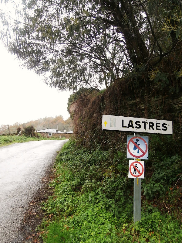
These are some signs in Lastres. It is evident that in this small village people are annoyed at pilgrims that take advantage of this lonely area to defecate.


We start here the section that leads us from Lastres to Freituxe.

We can see in the distance some houses in Renche in the roadside.

We can see another small water jump in the river.


A house in the Way. It seems to be inhabited.


Next to the entrance of the property the owners have placed these signs. Someone wrote on the top “No poppin and dancing”.

The River Oribio (also called Sarria).

We leave behind the house and keep walking.

The Way takes a slight slope.

The river accompanies the pilgrim throughout this stretch.

We look behind us at a moment of rest.

We arrive at Freituxe have walked 1 kilometre from Lastres. Firewood is ready to make good fire beside the first house we see on the Way in Freituxe.

Few metres further on we see the Church of the Virgen de la Salud (Our Lady of Health) in Freituxe.

End of Part 2.
Click Here for Part 3.
No comments:
Post a Comment